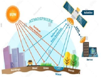
Remote sensingis a science of obtaining information about the earth’s surface
(Land and Ocean) and environment without touching them.
Electromagnetic Radiationsis the wave that propagates in the
space in speed of light.
Sensors is device to detect electromagnetic radiations reflect or emitted
from an object. Camera and scanners are example of sensors.
Platform is surfaces used to place camera or sensor to collect remote
sensing data. In early day’s balloons and aero planes but currently satellites
are used.
Satellite is any object that revolves around a planet.
Moon is the satellite of earth.
Satellite Imagerieshas three types.
Oblique Aerial Photography taken with the
camera inclined with an angle of about 30o from the vertical
axis.
Convergent Aerial Photographs are taken with two cameras
both fitted oblique.
Global Positioning System (GPS) it is
navigation and precise-positioning tool. It was developed by the US
department of defense in1973.
Geographical Information System (GIS)is a modern
technique of storing, retrieving and
transforming geographical data into maps, graphs and charts.
MCQs .
GPS stands
for………….
a) Grade Positioning System
b) Global Post System
c) Guarantee Positioning System
d)Global Positioning System
Which of the following is the science of
obtaining information about the Earth’s Surface (land, ocean) and environment
without touching them?
a) Geology
b) Remote Sensing
c) Far Sensing
d) GPS