Boundaries between different states are shown in…
a) Political Map
b) Relief Map
c) Vegetation Map
d) Commercial Map
The element of map which shows relationship between actual distance and the length on map is….
a) grid line
b) key line
c) legend line
d) scale
Physical Region
1) The area where geographical, social, and cultural environment is common is called a region.
2) Physical Region: The area where physical feature (climate, temperature, rain, soil, and altitude) are almost the same, is called physical region.
3) Physical region of pakistan: Pakistan is divide in to five parts or region in accordance with different surface features and climate conditions.
1) Mountain region
2) Plain region
3) Plateau
4) Coastal area
5) Desert
4) 1) Mountain Region: The world highest mountain ranges Karakuram, Himalyas and Hindukush are located in north and Noth west of Pakistan.
5) The world second highest mountain peak K-2 is located in same region.
6) Koh-e-Sulaiman and Kairther mountain ranges are located in North West.
7) 2) Plain Region: This is the most fertile region of Pakistan.
8) The river Indus and its tributaries i.e. Sutlej, Ravi, Chenab, And Jhelum flow in this region.
9) Lahore, Faisalabad, Multan and Hyderabad are situated in these plain areas.
10)3) Plateau: A high and flat area of the land having at least one sharp slope is called plateau. There are two plateaus in Pakistan.
1) Pothohar Plateau
2) Baluchistan Plateau
11)Pothohar Plateau: Pothohar Plateau is located between the Indus and Jhelum rivers. It is a dry land.
12)Rawalpindi, Islamabad, Jhelum and chakwal are located in this Pothohar plateau.
13)Baluchistan Plateau: It is rough and rocky area. Rain is rare in this area.
14)Underground canals have been built in some areas. These canals are called “Karez”.
15)The Tibet plateau is located in china.
16)4) Coastal area: Coastal area, along with the Arabian Sea, is located in the south of Pakistan.
17)It is widely spread from Karachi towards Baluchistan in the west.
18)“Bin-Qasim” port has been built up here and work is start on another big and modern port “Gawadar” in Baluchistan.
19)5) Deserts: Some locations of our country are dry and almost unpopulated. Neither cultivation, nor cattle rearing is possible due to lack of water and irrigation in this area. Such areas are called deserts or sandy area.
20)Pakistan Deserts:
1) Thal Deserts Punjab
2) Cholistan Deserts Punjab
3) Thar Desert Sindh
4) Kharan Deserts Baluchistan
Climate
1) Climate: The average weather conditions of a region
for a long time (about 30 years) is called climate.
2) There are some
factors which effect climate.
1) Distance from the equator
2)
Distance from the Sea
3) Altitude
from the sea level
4)Direction of wind
5)
Direction of mountain
6)
Ocean currents
3) The weather is
hot at the equator while cold at both the pole.
4) The world is
divided in to the following three large regions on the base of
latitude.
5) Torrid Zone (منطقہ حارہ): It is located between 23.5 degree to
the north and south of equator.
6) The weather of
these areas remains hot all the yearlong.
7) Temperate Zone (منطقہ
معتدلہ): The region is located between 23.50
and 66.50 in the northern and southern hemispheres. 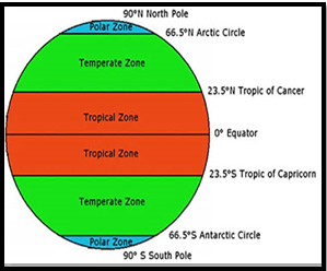
8) These areas
are warm in summer and cold in winter.
9) Frigid Zone (منطقہ باردہ): This region
is located between 66.50 and 900 in the northern
and southern hemispheres.
10)The weather of
these areas remains moderate in summer extremely cold in
winter.
11)Pakistan is
located in the north from tropic of cancer.
Therefore its climate should be moderate.
12)The climate
of our country is change from place to place because of its
physiographic and structure.
13)Climate of mountain region: The northern, north western and north eastern
hilly areas of Pakistan are up above the sea level.
14)The winter
season is long and extreme there. Similarly the summer season is
also moderates there.
15)Climate of the plains regions: Most of areas of Punjab and Sindh are
situated in Indus plain.
16)Summer season of Sindh and south Punjab is
very hot and long.
17)Climate of Baluchistan Plateau: Baluchistan plateau covers a vast area of
land. Its summer season is dry and hot while, winter season
is moderate.
18)Effect of
human activities on climate: Industries are rapidly increasing which
causes emission of the poisonous gases like carbon mono oxide and
chlorofluorocarbon (CFC).
19)Greenhouse
gases: The
atmospheric gases which absorb energy from the sun and restrain it to return
back in the atmosphere are called greenhouse gases.
20)Greenhouse
gases include carbon dioxide, carbon monoxide, water
vapors and dust particles.
21)Twister: Many times at some places the wind
starts blowing in circular motion this is called twister.
22)Cyclone: When twister circle wind cover an area of several
kilometers then it is called Cyclone.
The area where geographical, social, and cultural
environment is common is called a…..
a) society
b) culture
c) region
d) all of these
Which of the following is/are the physical region
a) climate, rain
b) temperature
c) soil, altitude
d) all of these