Geography (Globe and Map Skills) Unit No: 05
Longitudes
and latitudes
1) Map: Map is an easy source of information
about Earth.
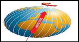
2) Longitudes (طول
بلد): The vertical line from north to south in
globe is called longitudes.
3) Longitude
divides in degrees.
4) Longitudes
degrees are 360. It’s calculated from Greenwich a
city of England.
5) Pakistan
position on map: On the map of world Pakistan is located at 23.420
to 36.550 north latitudes and 60.450
to 75.260 east longitude.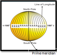
6) Prime meridian (نصف النہار اعظم ): The central line is on zero degree and called prime meridian.
1) Latitudes (عرض بلد): Parallel lines have been drawn on the globe
from east to west is called latitudes.
2) Latitudes
degrees are 180 in number (90 degree northern latitudes and 90
degrees southern latitudes.
3) Equator (خط
استوا): It is 00. The central line
between the latitudes lines which divides the earth in to two equal parts is
called equator. 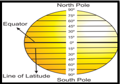
4) Tropic of cancer (خط
سرطان): This line is located at 23
5) Tropic of Capricorn (خط
جدی): This line is located at 23
6) Arctic line (دایرہ
قطب شمالی): Arctic line is located in the north of
equator at 66
7) Antarctic Line (دایرہ
قطب جنوبی): Antarctic line is located in the south of
equator at 66
8) Torrid Zone (منطقہ حارہ): The area between 23
9) Northern temperate
Zone (منطقہ معتدلہ شمالی): The Area between 23
10)Southern temperate
Zone (منطقہ معتدلہ جنوبی): The area between 23
11)Northern Frigid Zone
(منطقہ باردہ شمالی): The up area from 66
12)Southern Frigid zone
(منطقہ باردہ جنوبی ): The down area from 66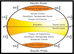
13)The book of map is called Atlas.
14)There are main two kinds of maps. 1) Need based map 2) Scale based maps
15)Need Based map: These maps are made for specific purpose for example physiographic, weather, population, earthquakes and floods etc.
16)Scale based Map: It has also two types. 1) Small scale map 2) Large scale map
17)Small scale map: In small scale maps a large part of the earth is shown through a single inch or a centimeter.
18)Large Scale Map: In the large scale maps comparatively, small part of the earth is shown through a single inch or centimeter.
19)Scale: Ratio between distances on the earth and map is called scale of the map.
20)Scale types: 1) Statement of scale 2) Linear Scale
21)Statement of scale: When the scale of a map is described in words it is called statement of scale. For example 1centimeter is equal to 10 kilometers. Which mean that one cm on the map shows 10 km of the ground.
22)Linear Scale: When the scale of a map is shown through a proper lengthy line, is called linear scale.
MCQs
An imaginary vertical line from north to south on globe
is called…….
a) Longitudes
b) Latitudes
c) Equator
d) none of these
There are……….degrees of longitude.
a) 90
b) 160
c) 360
d) 180